Introduction
California’s wind climate is shaped by a combination of large-scale atmospheric circulation patterns and diverse regional topography. From coastal breezes along the Pacific Ocean to desert gusts in the southeast, wind speeds and directions in the Golden State can vary dramatically over short distances.
The interplay of climate systems, topographic features, and land-sea temperature contrasts makes California a great case study for hyperlocal machine learning solutions that improve on large-scale numerical weather prediction models.
General Wind Patterns
- Spring-Early Fall
During this period, the North Pacific High (a semi-permanent high-pressure system off the West Coast) dominates California’s weather. Coastal and valley areas experience a regular sea breeze, with mild to moderate afternoon winds.
- Late Fall-Winter
As the Pacific High weakens or shifts westward, frontal systems more frequently impact the state, bringing stronger westerly or southwesterly winds, especially in Northern and Central California.
- Santa Ana Winds
Often associated with Southern California, these offshore, hot, dry, and gusty winds typically blow in fall and winter. Speeds of 10-15 m/s are common, with gusts exceeding 25 m/s in canyon or pass areas (e.g., Santa Clarita, Malibu).
Influence of Topography and Localized Effects
- Channeling & Microclimates
Coastal plains, mesas, and inland valleys create localized channeling effects, where terrain can amplify or diminish wind speeds. Bluffs enhance uplift and turbulence, while canyons funnel winds to locally higher velocities.
- Urban Development & Land Cover
Built environments, forests, and other land cover variations significantly influence near-surface wind flow. These small-scale effects can cause existing weather forecasts to be insufficiently accurate, especially in complex terrain.
As a result, precise wind predictions all over the state are vital for unlocking the full potential of transmission and distribution assets. However, standard numerical weather models often struggle to capture fine-grained variability, prompting the need for hyperlocal machine learning approaches.
Improving accuracy by 50%
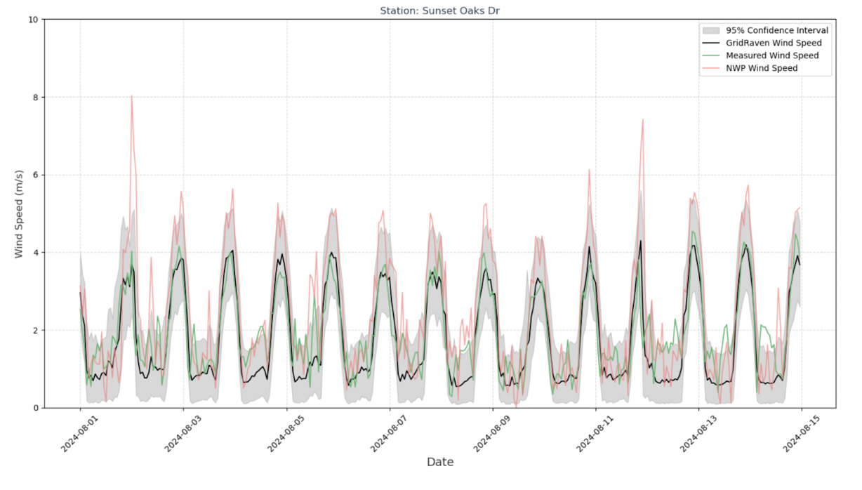
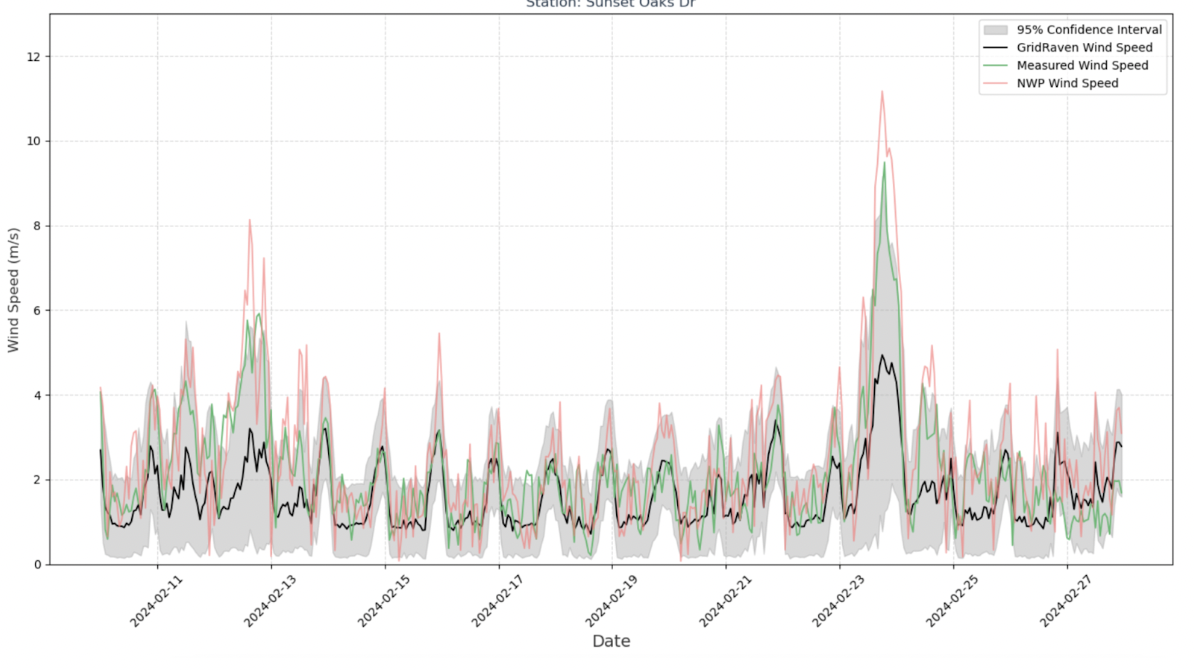
Below are examples (for both summer and winter cases) from the San Diego region, showcasing wind speed measurements (green line), numerical weather predictions (red line), and Gridraven’s machine learning model (black line) with 95% confidence intervals (shaded in gray).

Fig 1. Example wind speed prediction (black) compared to measurements (green) and numerical weather predictions (red) in the San Diego region - summer period.

Fig 2. Example wind speed prediction (black) compared to measurements (green) and numerical weather predictions (red) in the San Diego region - winter period.
The model had no prior access to these specific measurements or locations (i.e., they were in the test set). Evidently, the observed winds stay within the 95% confidence intervals.
Sensorless Dynamic Line Rating Solution
This 50% accuracy improvement in wind speeds plus robust confidence intervals enables fully sensorless Dynamic Line Ratings on sections of the grid that traverse difficult terrain (forests, plains, valleys, etc.). It is a significant advancement towards reducing grid congestion, improving transmission capacity, minimizing energy costs and maximizing the existing grid potential.
By combining machine learning with weather modeling, we can help California’s utilities make informed decisions to enhance safety and boost efficiency across the state’s electrical grid.


